TaipeiEcon
Inventory of all articles of TaipeiEcon
Inventory of all articles of TaipeiEcon
Common issues in urban management include large areas, complex terrain, and constantly changing conditions on the ground. UAVs provide an additional source of information to complement ground-based inspections. Taipei City Government combines aerial observation with existing inspection and management operations, using sensing, AI, and geospatial tools as needed. Aerial imagery is used to identify anomalies and support construction management, expanding the application of technology in municipal operations.
In Taipei City, urban management operations include environmental inspection, slopeland management, and public construction. On-site inspections are essential in many tasks for keeping track of actual conditions on the ground. However, for large management areas, complex terrain, or constantly changing construction sites, on-site inspections alone may not always provide the necessary information in a timely manner.
Taipei City Government has introduced UAVs into municipal operations to complement existing inspection methods through aerial observation. Depending on management needs, UAVs are used in combination with air quality sensors, satellite imagery, AI-assisted image interpretation, geospatial information, and engineering management systems. The information collected can be used to monitor current conditions, screen for anomalies, compare construction progress, and support construction management and follow-up inspections.
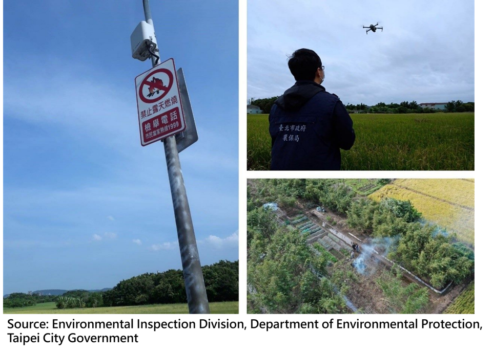
Open burning tends to occur at scattered locations and irregular times. Detecting such pollution promptly is an important challenge for environmental inspections. In the Guandu Plain and Shezidao, for example, the Department of Environmental Protection, Taipei City Government, installed air quality sensors in pollution hotspots to track changes in air quality. High-altitude patrols are also conducted by UAVs to rapidly monitor large areas. Monitoring data and aerial imagery are used to identify potential pollution locations, which are then further investigated by inspectors. Based on the program results published in 2025, the number of complaints regarding open burning in the Guandu Plain dropped from 66 cases in 2014 to 2 cases in 2024. Straw burning has decreased significantly following years of inspections and related preventive measures.
Slopeland accounts for approximately 55% of Taipei City's total area. The Geotechnical Engineering Office (GEO) of the Public Works Department, Taipei City Government, uses satellite imagery to monitor surface changes across large areas, such as new buildings, land grading, and road construction as part of its efforts to protect the natural environment and strengthen slopeland management. Since 2024, AI-assisted image interpretation has also been introduced to automatically identify potential anomalies. AI-assisted image interpretation achieves three times the efficiency of traditional manual interpretation. Automatic classification achieves an accuracy rate of over 92%, helping reduce the time required for image interpretation. For locations that are difficult to verify from satellite imagery or require further investigation, UAVs can provide close-range imagery to support assessment and on-site inspection by field inspectors.
During soil and water conservation projects, the terrain, work areas, and conservation facilities change continuously as construction progresses. Monitoring construction conditions and verifying that the work is being carried out as approved are important parts of construction inspection. In the past, ground-based inspections were often constrained by terrain and limited viewing angles. Since GEO introduced UAVs into construction inspections, inspectors have been able to obtain a more complete aerial view of construction areas and supplement information that is difficult to gather from the ground.
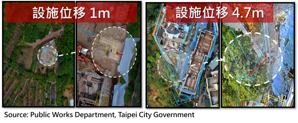
GEO regularly conducts aerial photography for soil and water conservation projects. UAV imagery is overlaid with satellite imagery to create high-precision 2D and 3D models of construction sites. The models are then compared with approved soil and water conservation plans at different stages of construction. Imagery from different stages of construction shows the before-and-after changes to the construction site. Inspectors can assess current conditions and use historical data to track construction progress and identify deviations in facility locations. If any deviations from the approved plans are identified, GEO requires corrective action.
At the same time, GEO incorporates the aerial survey results into the "TGEO Spatial Geographic Information Platform," integrating soil and water conservation cases with related geospatial data. Construction records provide access to 3D models, orthophotos, and engineering drawings, allowing aerial survey results from different stages of construction to be reviewed and used over time. Building on the accumulated aerial survey data, GEO has also introduced AI-based disaster prevention tools. Aerial imagery is used to train AI models to identify construction issues and reduce the time required for manual interpretation.
In 2025, the Department of Rapid Transit Systems, Taipei City Government (DORTS) won the Merit Award in the Advancement Category of the Taipei City Government Creative Proposal Competition with its submission on "Application of Technology for Disaster Prevention in Mass Rapid Transit Engineering" for Contract CQ890 of MRT Wanda Line Phase II. MRT projects often involve extensive alignments and multiple construction areas. In the past, inspections were conducted mainly on-site by personnel, which was labor-intensive and time-consuming and did not always provide a complete picture of the construction site and its surroundings. UAVs were therefore introduced for Contract CQ890. UAV inspections were conducted once a month to record the construction alignment, work areas, and surrounding environment from a broader aerial perspective.
The high-resolution photos and videos acquired by the UAV are organized and reviewed before being uploaded to the cloud platform. Engineering personnel can then review historical records to compare site conditions over time. If a potential construction issue is discovered, a follow-up on-site inspection can be conducted and safety measures taken. Regular aerial monitoring and archived imagery allow engineering personnel to track changes in the work area without relying solely on on-site inspections, while also preserving more complete records of construction activities and the surrounding environment.
Contract CQ890 has also incorporated UAV inspections into its technology-based disaster prevention measures. UAVs are used in combination with structural tilt monitoring, Building Information Modeling (BIM), AI gas detection, mobile CCTV, and environmental and weather monitoring to monitor surrounding buildings, construction conditions, and site safety. The information supports on-site management and safety inspections.
Across different municipal applications, UAVs provide aerial information that complements existing inspection and management processes and supports on-site assessment and follow-up actions. Through these applications, Taipei City continues to build experience in adopting emerging technologies for urban governance. As UAVs, AI, and other digital technologies continue to evolve, Taipei City will continue to expand their applications in technology governance, contributing to a smarter and safer city.